Teleport your device anywhere instantly with one click.


 100% Security Verified | No Subscription Required | No Malware

 :

 ChatGPT
 Perplexity
 Gemini
 Claude
 Grok
PokeCrew no longer opens on my Android phone. Which map resources are worth checking instead?

A PokeCrew map alternative is useful only when its information covers your area and is recent enough to act on. An app package that remains downloadable can outlive the servers supplying its map. Likewise, an impressive number of markers does not establish that the reported Pokemon are still present.
This 2026 review keeps the eight options from the original comparison but does not label all eight active. Some are legacy Android resources, some offer a current web page or store listing, and the old Silph Road mapping service has closed. Use the distinctions below to avoid confusing historical availability with a verified live sighting.
In this article
Part 1: Can You Still Rely on PokeCrew?
The original PokeCrew experience centered on a shared map of reported Pokemon activity. The older article pointed Android users toward an APK because the app was no longer readily available through the normal store. That workaround does not establish that the service still receives data, nor does the available evidence support blaming a particular company for every store removal.
The retained APK reference is Try It Free. Treat it as a legacy source link, not an instruction to install an unknown file. This review has not downloaded, executed or security-tested that package. Avoid supplying game credentials to an unofficial app and do not disable device protection merely to make an old package run.
- Sighting markers: PokeCrew was described as showing reported spawn positions. Check the report time rather than treating a marker as an active encounter.
- Spawn duration: historical timers are useful only if the underlying report and clock are current.
- Other map layers: gyms, raids, nests and PokeStops represent different kinds of information; a stable gym marker does not validate nearby live spawns.
- Species filtering: selecting a Pokemon narrows the displayed records but cannot reveal an unreported or unavailable spawn.
Some older guides promote hacks for catching pokemon go without walking. That label does not override the game's rules or make remote catches reliable. Prefer current in-game information and lawful local exploration when a community map cannot provide trustworthy reports.
Part 2: Compare the Eight PokeCrew Alternatives
Evaluate each resource on three separate questions: can you access it, does it cover your location, and does it provide the type of information you need? A store listing answers only the first question. Crowd-sourced reports also depend on local contributors, and archived APK pages cannot prove that a live backend survives.
1. Go Radar Pokemon Scanner
Go Radar was presented as a simple Android scanner with a species filter and a free map interface. Its attraction was quick nearby lookup without navigating a complex directory. The original comparison also acknowledged infrequent updates, an important limitation for sightings that expire quickly.
- Original use case: view reported positions and filter for a particular species.
- Potential convenience: a straightforward interface for a short local check, if a functioning version and data source are available.
- Current limitation: the exact Google Play URL below returned 404 during this review. Do not describe that listing as currently downloadable or its data as live.
Original store reference: https://play.google.com/store/apps/details?id=com.eighteen.goradar&hl=en
2. WeCatch for Pokemon Go
WeCatch offers a map-oriented approach with species filters and information about Pokemon, gyms, raids and PokeStops. The linked Taiwan App Store page is accessible and describes rare-Pokemon notifications, nearby searches and information sharing. It identifies the app as a fan project rather than an official Pokemon GO service.
- Useful functions: filters, nearby searching and reported raid or encounter information can reduce manual browsing.
- Timing information: when a timer is displayed, use it alongside the report's freshness rather than as proof that an encounter remains catchable.
- Limits: the older article also mentioned Android, but this review verifies the linked iOS listing, not a current Android distribution. The present listing requires iOS 16 or later; regional store access and local data coverage can differ.
Store page: https://apps.apple.com/tw/app/wecatch-%E9%9B%B7%E9%81%94-%E5%9C%B0%E5%9C%96/id1137814668
3. Poke Radar
Poke Radar's original appeal was an interactive atlas: inspect nearby reports, move the map to another area and look for additional points of interest such as gyms or raids. That browsing model is useful for planning, but a directory cannot guarantee that every species has been reported.
- Original functions: nearby sighting lookup, map navigation and information for other locations.
- Coverage weakness: the source explicitly noted missing Pokemon entries, so an empty result need not mean the species is absent from the game.
- Availability caution: the retained link is a third-party package page. A current official store release and operating map service are not verified here.
Legacy package reference: https://apkpure.com/poke-radar-for-pokemon-go/com.pokeradar
4. Poke Live Map
The JV Studios Poke Live listing describes scanning an area, showing reported Pokemon and displaying time remaining. The archived release page remains readable, but its assertions about complete real-time accuracy are marketing claims, not a live-data test conducted for this article.
- Original map scope: the comparison described sightings, nests, stops, gyms and raids.
- Practical value: a fresh countdown could help decide whether a nearby report is worth checking, if the service actually supplies current data.
- Limitations: updates were already described as irregular. The archived version page does not prove present-day compatibility with leading Android devices or an active backend.
Archived release: https://www.apkmirror.com/apk/jv-studios/poke-live-for-pokemon-go/poke-live-for-pokemon-go-1-1-release/
5. Radar Go for Android
Radar Go was aimed at trainers checking reports around their current position. Its described workflow combined nearby results and spawn timers with browsing another place. The original directory also allowed users to contribute sighting or nest locations, making report quality dependent on community input.
- Best original fit: a local search followed by comparison with another mapped area.
- Contribution feature: adding reports can improve a directory, but mistaken or outdated submissions can also reduce its reliability.
- Distribution limit: the source said the app was no longer on Google Play. The third-party reference below is not confirmation of current support or trustworthy active sightings.
Legacy reference: https://www.malavida.com/en/soft/radar-go/android/
6. The Silph Road
The Silph Road previously maintained a major community resource, including a nest atlas and community maps. Its value came from player contributions and research, rather than a guarantee that every wild Pokemon could be located in real time. Species filtering and sorting could also take time in a large collection of reports.
- Historical strengths: community knowledge, reported nests and tools that helped trainers compare locations.
- Important correction: the team announced closure of its web services, and the old community map and nest atlas are no longer an active recommendation.
- Do not confuse resources: an ongoing discussion community or archived research is not the former live map service.
Original website reference: https://thesilphroad.com/
7. PoGo Map
PoGo Map is a browser-based resource whose current help text describes crowd-sourced locations, user additions and voting on PokeStops and gyms. Its controls also mention reporting or viewing raid and task information. This makes it more useful to evaluate as an infrastructure and community-report map than as a guaranteed live Pokemon scanner.
- Planning functions: inspect mapped points, addresses or coordinates where supplied, and choose relevant layers.
- Data model: local contributions and corrections matter; the site says its data is crowd-sourced.
- Limit: its current page labels worldwide Pokemon sighting reporting as coming soon. The older claim of exact live spawn coverage should therefore not be treated as established. Use the website rather than assuming an old mobile app is supported.
Website: https://www.pogomap.info/
8. Poke Map
PokeMap's accessible site describes a collaborative Pokemon map. Users can add discoveries, select a species to search and show gyms or PokeStops. Such filters are a convenient way to focus a busy map, but the result is only as useful as the reports contributed in that area.
- Useful fit: comparing community-reported sightings and nearby points of interest in a covered location.
- Scope check: the original comparison also mentioned raid details; inspect the actual layers available rather than assuming every described feature exists everywhere.
- Coverage caution: do not promise worldwide completeness. A marker or species selection cannot guarantee current presence, accurate timing or a successful catch.
Website: https://www.pokemap.net/
Pro Tip: Understand GPS Simulation Before Attempting Remote Play
 Set your map route to simulate GPS movement.
- Set your wanted movement speed.
- HD and large map view to check location.
- Fake GPS location to anywhere.
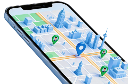
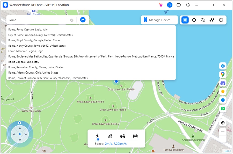
A map report tells you where someone reported an encounter; it does not move your phone or create a Pokemon there. Dr.Fone - Virtual Location is a separate desktop tool for choosing a simulated GPS position on supported iOS and Android configurations. Its map search accepts a place, address or coordinates.
The tool also offers route simulation and joystick navigation, but these features cannot guarantee acceptance by Pokemon GO or a successful encounter. The game's official fairness policy identifies GPS location spoofing as cheating and warns of account penalties. Do not interpret the supplied product banner's marketing language as proof of account safety; use location testing only where permitted.
Step 1 Connect a supported device
Open the desktop location module, connect the phone and complete its authorization prompts. Confirm current compatibility before starting rather than assuming an old screenshot applies to every system release.
Step 2 Search and inspect the map
Choose Teleport Mode and enter the intended location. Review the marker, then use Move Here when it is correct. Coordinates copied from an old sighting remain an old sighting even if the device location changes successfully.
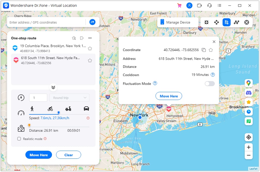
For a permitted route simulation, place points to define a path and choose an appropriate speed. The joystick provides an alternative way to adjust simulated movement. Neither slower travel nor a particular route establishes immunity from a game's enforcement systems.
Verify the result in the phone's map, and follow the tool's restart-device guidance to restore actual GPS afterward. The demonstration video is retained for interface context; it is not evidence that current game versions allow the workflow.




Conclusion
The best replacement for PokeCrew depends on the information you need now: an accessible local reporting map, a store-listed app with relevant coverage or historical community research. Keep all eight names in perspective rather than treating every legacy download as active. Check timestamps and in-game conditions, and remember that GPS simulation does not validate reports, generate rare Pokemon or remove account risk.
FAQ
1. Does a PokeCrew APK prove the map still works?
No. The application package and its data service are separate. A surviving download page does not establish current server availability, accurate sightings or package safety.2. Are all eight alternatives active in 2026?
No. The list includes legacy resources. The original Go Radar store link returned 404, and the former Silph Road web map is closed; other resources need local coverage checks.3. Is a gym map also a live Pokemon radar?
Not necessarily. Gym and PokeStop positions can remain useful longer than an individual spawn. Confirm what each layer reports and when the information was last updated.4. Does GPS simulation guarantee remote catches without penalties?
No. It cannot create an encounter or guarantee game acceptance, and the official Pokemon GO fairness policy prohibits falsifying location.
 Add Wondershare Dr.Fone as a preferred source on Google